Telemetry
The help for this page of the Version 2 transmitter, in its newest words. A transmitter on V2 B92 or older shows older words.
On the transmitter: Model setupTelemetry
Telemetry: how well the radio link is working, and what the model reports. Look at it after a flight, before you switch off.
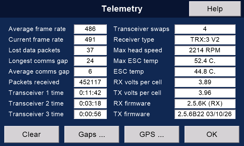
'Clear' sets the counts back to zero: lost packets, the comms gaps (and the 'Gaps ...' page), the frame rates, and the GPS page's maximum speed and distance.
They also start again a few seconds after each connection, and when you press 'OK' on 'Rotorflight options'.
'Gaps ...' shows how long each reconnection took.
'GPS ...' opens the GPS page.
The link
Average and current frame rate: packets received each second.
Lost data packets: packets that did not arrive.
Longest comms gap: the most milliseconds between losing a data packet and being connected again. Below about 250 (a quarter of a second) all should be well; normally it is well below 100.
If it is much higher, move the receiver's aerials, and check them for damage. Dipole aerials are recommended.
Average comms gap: the average length of the gaps (ms).
Packets received: as counted by the receiver.
Transceivers
Receiver type: TRX is how many transceivers it has (TRX:2 = two). V2 means a Version 2 receiver.
PWM:8 or PWM:11: the servo outputs of a Version 1 receiver.
Transceiver swaps: how often the receiver changed over from one transceiver to another.
Transceiver 1, 2 and 3 time: how long each has been in use.
The model
Max head speed, Max ESC temp and ESC temp come from Rotorflight.
RX volts per cell: the model's battery.
TX volts per cell: the transmitter's battery.
RX and TX firmware: the version numbers.
Altitude
Altitude is not shown on this page.
A Version 1 receiver with a BMP280 pressure sensor measures it.
With 'Keep log files' on, the highest altitude goes into the log when the model disconnects.
The sensor needs the local sea-level pressure (QNH).
Enter it in 'Sea-level pressure (QNH)', on page 3 of Transmitter setup / 'System'. A nearby airfield's web site, or an AI assistant, will tell you.
To measure from where you stand, press 'Zero alt' on the GPS page with the model on the ground.
Pressure altitude is usually right to within a foot or so, far better than altitude from GPS.
Still stuck?
See common questions, or write to mmessiter@gmail.com. Say which page, and what the screen showed.